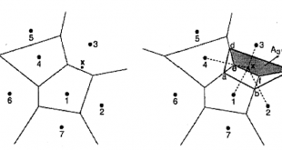
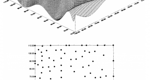
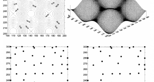
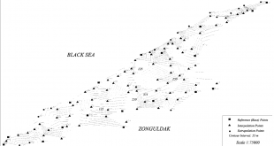
Uluslararası Hakemli Dergilerdeki Yayınlar

Digital Elevation Model Based Volume Calculations Using Topographical Data

JOURNAL OF SURVEYING ENGINEERING-ASCE, Vol. 129, No. 2, 2003, s. 56-64, ISSN: 0733-9453 Digital Elevation Model Based Volume Calculations Using Topographical Data M.Yanalak, O.Baykal Abstract: Volume calculations based on a digital elevation model (DEM) are widely used instead of traditional handmade cross-sectioning methods on contour maps. Cross sections can be …

Devamını Oku..

Selection of PolSAR Observables for Crop Biophysical Variable Estimation With Global Sensitivity Analysis

IEEE GEOSCIENCE AND REMOTE SENSING LETTERS, cilt.16, sa.5, ss.766-770, 2019 Selection of PolSAR Observables for Crop Biophysical Variable Estimation With Global Sensitivity Analysis Erten E. , Taşkın Kaya G. , Lopez-Sanchez J. M. Abstract: The role of global sensitivity analysis (GSA) is to quantify and rank the most influential features …

Devamını Oku..

The worsening impacts of land reclamation assessed with Sentinel-1: The Rize (Turkey) test case

INTERNATIONAL JOURNAL OF APPLIED EARTH OBSERVATION AND GEOINFORMATION, cilt.74, ss.57-64, 2019 The worsening impacts of land reclamation assessed with Sentinel-1: The Rize (Turkey) test case Erten E. , Rossi C. Abstract: Massive amounts of land are being reclaimed to build airports, new cities, ports, and highways. Hundreds of kilometers are …

Devamını Oku..

Assessment of Paddy Rice Height: Sequential Inversion of Coherent and Incoherent Models

IEEE JOURNAL OF SELECTED TOPICS IN APPLIED EARTH OBSERVATIONS AND REMOTE SENSING, cilt.11, sa.9, ss.3001-3013, 2018 Assessment of Paddy Rice Height: Sequential Inversion of Coherent and Incoherent Models Yüzügüllü O., Erten E. , Hajnsek I. Abstract: This paper investigates the evolution of canopy height of rice fields for a complete …

Devamını Oku..

Retrieval of vegetation height in rice fields using polarimetric SAR interferometry with TanDEM-X data

REMOTE SENSING OF ENVIRONMENT, cilt.192, ss.30-44, 2017 Retrieval of vegetation height in rice fields using polarimetric SAR interferometry with TanDEM-X data Lopez-Sanchez J. M. , Vicente-Guijalba F., Erten E. , Campos-Taberner M., Javier Garcia-Haro F. Abstract: This work presents for the first time a demonstration with satellite data of polarimetric …

Devamını Oku..

Retrieval of agricultural crop height from space: A comparison of SAR techniques

REMOTE SENSING OF ENVIRONMENT, cilt.187, ss.130-144, 2016 Retrieval of agricultural crop height from space: A comparison of SAR techniques Erten E. , LOPEZ-SANCHEZ J. M. , YUZUGULLU O., HAJNSEK I. Abstract: This paper deals with the retrieval of agricultural crop height from space by using multipolarization Synthetic Aperture Radar (SAR) …

Devamını Oku..
UHUZAM