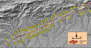
Uluslararası Hakemli Dergilerdeki Yayınlar

Remote sensing approaches and mapping methods for monitoring soil salinity under different climate regimes

International Journal of Environment and Geoinformatics, March 2019 Remote sensing approaches and mapping methods for monitoring soil salinity under different climate regimes Taha Gorji, Aylin Yildirim, Elif Sertel, Aysegul Tanik Abstract: Soil salinization is one of the severe land-degradation problems due to its adverse effects on land productivity. Each year …

Devamını Oku..

Estimation of emissions from crop residue burning using remote sensing data

Int. J. Global Warming., 2019, 1758-2083, 19, 1-2, 94-105 Estimation of emissions from crop residue burning using remote sensing data Kubra Bahsi, Betul Sallı, Dogushan Kilic, Elif Sertel Abstract: Approximately one-fourth of the population in Turkey works in the agricultural sector. One common problem in agricultural waste removal is the …

Devamını Oku..

Comparing two different spatial interpolation approaches to characterize spatial variability of soil properties in Tuz Lake Basin – Turkey

Fresenius Environmental Bulletin Journal, 28(2), 2019 pages 638-644 –SCI Comparing two different spatial interpolation approaches to characterize spatial variability of soil properties in Tuz Lake Basin – Turkey Gorji, T., Alganci, U., Sertel, E., Tanik, A. Abstract: The main objective of this study is to compare the performance of two …

Devamını Oku..

An Approach for the Pan Sharpening of Very High Resolution Satellite Images Using a CIELab Color Based Component Substitution Algorithm

Applied Sciences, 9, 5234 An Approach for the Pan Sharpening of Very High Resolution Satellite Images Using a CIELab Color Based Component Substitution Algorithm Rahimzadeganasl, A.; Alganci, U; Goksel, C. Abstract: Recent very high spatial resolution (VHR) remote sensing satellites provide high spatial resolution panchromatic (Pan) images in addition to …

Devamını Oku..

Dynamic Land Cover Mapping of Urbanized Cities with Landsat 8 Multi-temporal Images: Comparative Evaluation of Classification Algorithms and Dimension Reduction Methods

ISPRS Int. J. Geo-Inf. 8(3), 139 Dynamic Land Cover Mapping of Urbanized Cities with Landsat 8 Multi-temporal Images: Comparative Evaluation of Classification Algorithms and Dimension Reduction Methods Alganci, U Abstract: Uncontrolled and continuous urbanization is an important problem in the metropolitan cities of developing countries. Urbanization progress that occurs due …

Devamını Oku..

A comparative analysis of gridding systems for point-based land cover/use analysis

Geocarto International, 34(8), 867-886 A comparative analysis of gridding systems for point-based land cover/use analysis Shoman, W., Alganci, U., Demirel, H. Abstract: For spatial analyses, raster land cover/use maps are converted into points, where each point holds attribute of its corresponding land cover/use. However, these are not identical in terms …

Devamını Oku..

The use of broadband vegetation indices in cultivated land detection with Landsat 8 OLI multi-temporal images

Fresenius Environmental Bulletin, 28(2), 546-551 The use of broadband vegetation indices in cultivated land detection with Landsat 8 OLI multi-temporal images Alganci, U. Abstract: Determination of cotton and maize cultivated areas with multi-temporal satellite images using vegetation indices is the main objective of this research. Study area was located on …

Devamını Oku..

Dynamic monitoring of land coverchange: a recent study for Istanbul metropolitan area

Fresenius Environmental Bulletin, 28(2), 688-693 Dynamic monitoring of land coverchange: a recent study for Istanbul metropolitan area Shoman,W., Korkutan, M., Alganci, U., Tanik, A., Demirel, H. Abstract: In this study, the changes in land cover/use is detected using remote sensing, GIS and stochastic modelling for part of metropolitan Istanbul city. …

Devamını Oku..

Dual-band Frequency Surface Design by Implementing a Simple Design Technique

IETE Journal of Research (TIJR), 09 Dec. 2019 Dual-band Frequency Surface Design by Implementing a Simple Design Technique B. Doken, M. Kartal Abstract: Mutual interference between wireless devices in indoor environment reduces system performance. Ensuring secure personal communication within such wireless networks is also another important problem. Existing indoor surfaces can …

Devamını Oku..

Analyzing gridding systems for land cover/land use information: astudy conducted for green areas

Fresenius Environmental Bulletin, 28(2), 694-699 Analyzing gridding systems for land cover/land use information: astudy conducted for green areas Shoman,W., Alganci, U., Demirel, H. Abstract: Performing point-based land cover/use analysis traditionally compels converting thematic clusters into representative points located at their corresponding centroids. Yet, various spatial analyses require to grid thematic …

Devamını Oku..
UHUZAM