REMOTE SENSING OF ENVIRONMENT, cilt.192, ss.30-44, 2017
Retrieval of vegetation height in rice fields using polarimetric SAR interferometry with TanDEM-X data
Lopez-Sanchez J. M. , Vicente-Guijalba F., Erten E. , Campos-Taberner M., Javier Garcia-Haro F.
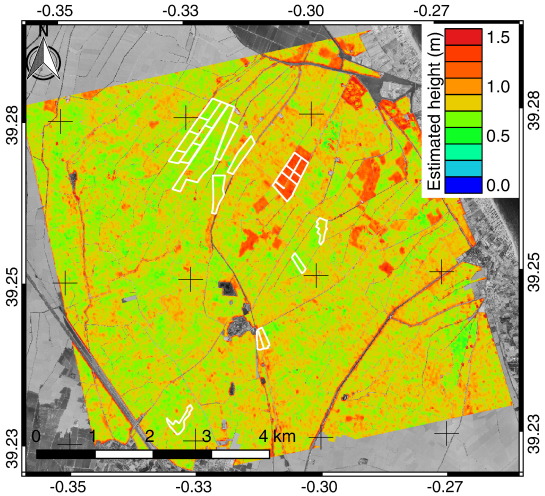
Abstract: This work presents for the first time a demonstration with satellite data of polarimetric SAR interferometry (PolInSAR) applied to the retrieval of vegetation height in rice fields. Three series of dual-pol interferometric SAR data acquired with large baselines (2-3 km) by the TanDEM-X system during its science phase (April September 2015) are exploited. A novel inversion algorithm especially suited for rice fields cultivated in flooded soil is proposed and evaluated. The validation is carried out over three test sites located in geographically different areas: Sevilla (SW Spain), Valencia (E Spain), and Ipsala (W Turkey), in which different rice types are present. Results are obtained during the whole growth cycle and demonstrate that PolInSAR is useful to produce accurate height estimates (RMSE 10-20 cm) when plants are tall enough (taller than 25-40 cm), without relying on external reference information. (C) 2017 Elsevier Inc. All rights reserved.
Available Online: https://www.sciencedirect.com/science/article/abs/pii/S0034425717300536?via%3Dihub