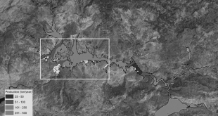
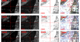
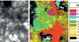
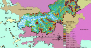
Uluslararası Hakemli Dergilerdeki Yayınlar

Analysis of Land Cover/Use Changes Using Landsat 5 TM Data and Indices

Environmental Monitoring and Assessment, 189(4), Article Number: 136, DOI 10.1007/s10661-017-5818-5. (2017) Analysis of Land Cover/Use Changes Using Landsat 5 TM Data and Indices Ettehadi Osgouei, P., Kaya, Ş. Abstract: Urban expansion and unprecedented rural to urban transition, along with a huge population growth, are major driving forces altering land cover/use …

Devamını Oku..

A Comparative Analysis of Classification Methods for Hyperspectral Images Generated with Convential Dimension Reduction Methods

Turkish Journal Of Electrical Engineering & Computer Sciences, 25 (1), 58-72. (2017) A Comparative Analysis of Classification Methods for Hyperspectral Images Generated with Convential Dimension Reduction Methods Arslan, O., Akyurek, Ö., Kaya, Ş. Abstract: This paper compared performances of classification methods for a hyperspectral image dataset in view of dimensionality …

Devamını Oku..

Investigation Of Morphometric and Hydrological Characteristics of a Water Basin Using Numerical Models

Fresenius Environmental Bulletin, 26 (1), 360-368. (2017) Investigation Of Morphometric and Hydrological Characteristics of a Water Basin Using Numerical Models Kaya, Ş., Kutukcu, A Abstract: Defining the characteristics of a basin is extremely important in terms of its maximum utilization rate. Impact of the basin structure and morphological characteristics on the hydrological processes is essential during conducting a research on a …

Devamını Oku..

Determination Of Conservation Areas and Tracking Sustainability With Lucis Models: A Case Study Of Istanbul

Fresenius Environmental Bulletin, 26 (1), 369-374. (2017) Determination Of Conservation Areas and Tracking Sustainability With Lucis Models: A Case Study Of Istanbul Taşdemir, I., Kaya, Ş. Abstract: Two Bosporus bridges –built in 1973 and 1988, turned the direction of Istanbul’s urban expansion to the north. Hosting 20% of Turkey’s population, …

Devamını Oku..

Analysis of Different Interpolation Methods for Soil Moisture Mapping Using Field Measurements and Remotely Sensed Data

International Journal of Environment and Geoinformatics , 3, 11-25, (2016) Analysis of Different Interpolation Methods for Soil Moisture Mapping Using Field Measurements and Remotely Sensed Data Abstract: In this research, we comparatively analyzed different interpolation methods to create soil moisture maps by using field measurements and remotely sensed data. Impacts …

Devamını Oku..

Evaluation of Spatio-Temporal Variability in Land Surface Temperature: A Case Study Of Zonguldak, Turkey”

Environmental Monitoring and Assessment, 188(1), Article Number: 30, DOI: 10.1007/s10661-015-5032-2. (2016) Evaluation of Spatio-Temporal Variability in Land Surface Temperature: A Case Study Of Zonguldak, Turkey” Abstract: The aim of this study is to analyze spatio-temporal variability in Land Surface Temperature (LST) in and around the city of Zonguldak as a …

Devamını Oku..

Scour Patterns Around Isolated Vegetation Elements

Advances Water Resources,  97, 251-265. (2016) Scour Patterns Around Isolated Vegetation Elements Yagci O., Celik F., Kitsikoudis V., Kirca V.S.O., Hodoglu C., Valyrakis M., Duran Z., Kaya S. Abstract: The complex multi-directional interactions between hydrological, biological and fluvial processes govern the formation and evolution of river landscapes. In this context, …

Devamını Oku..

Evaluation of spatio temporal variability in Land Surface Temperature A case study of Zonguldak Turkey

Environmental Monitoring and Assessment, Vol. 188, No. 1, Ocak 2016, ISSN: 0167-6369 Evaluation of spatio temporal variability in Land Surface Temperature A case study of Zonguldak Turkey Şekertekin Ali İhsan, Kutoğlu Şenol Hakan and Kaya Şinasi Abstract: The aim of this study is to analyze spatio-temporal variability in Land Surface …

Devamını Oku..

Comparison of pixel and object based classification approaches for Burned Area Mapping using SPOT-6 images

Geomatics, Natural Hazards and Risk, 7, 4, DOI:10.1080/19475705.2015.1050608, 1198-1206 Comparison of pixel and object based classification approaches for Burned Area Mapping using SPOT-6 images Sertel, E. and Alganci, U Abstract: On 30 May 2013, a forest fire occurred in Izmir, Turkey causing damage to both forest and fruit trees within …

Devamını Oku..
UHUZAM