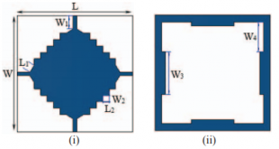
2017 25th Signal Processing and Communications Applications Conference (SIU) Design of wideband MIMO antenna for wireless applications Abubeker A Yussuf, Selcuk Paker Abstract: A wideband multiple input multiple output (MIMO) antenna was designed and fabricated for a wireless device at the operating frequency bands 2.1/2.3/2.6 GHz for LTE and 2.4GHz …
Devamını Oku..Ground Moving Targets Refocusing Algorithm for Spotlight SAR Data
Proceedings of EUSAR 2016: 11th European Conference on Synthetic Aperture Radar Ground Moving Targets Refocusing Algorithm for Spotlight SAR Data I. Papila, S. Paker, M. Kartal, S. Kent Abstract: A new target-subpatch technique based-on re-centering phase computation of previously recorded raw data will be implemented to the Spotlight SAR data …
Devamını Oku..Use of remote sensing and geographic information systems in the determination of high-risk areas regarding marine traffic in the Istanbul Strait
ENVIRONMENTAL HAZARDS-HUMAN AND POLICY DIMENSIONS, cilt.14, sa.1, ss.54-73, 2015 Use of remote sensing and geographic information systems in the determination of high-risk areas regarding marine traffic in the Istanbul Strait Musaoğlu N. , Tanik A. G. , DIKERLER T., BUHUR S. Abstract: Istanbul Strait, Bosphorus, is one of the important …
Devamını Oku..Refocusing of moving targets in Spotlight SAR raw data
2015 23nd Signal Processing and Communications Applications Conference (SIU) Refocusing of moving targets in Spotlight SAR raw data İ. Papila, S. Paker, M. Kartal, S. Kent Abstract: In this paper a method for moving targets detection based on Spotlight Synthetic Aperture Radar (SAR) images is proposed and tested in simulation …
Devamını Oku..Impact of the Ataturk Dam Lake on Agro-Meteorological Aspects of the Southeastern Anatolia Region, Turkey
JOURNAL OF THE INDIAN SOCIETY OF REMOTE SENSING, cilt.46, sa.3, ss.471-481, 2018 Impact of the Ataturk Dam Lake on Agro-Meteorological Aspects of the Southeastern Anatolia Region, Turkey Özcan O. , Bookhagen B., Musaoğlu N. Abstract: In this study, the spatial and temporal impacts of the Ataturk Dam on agro-meteorological aspects …
Devamını Oku..Comparison of Planimetric and Thematic Accuracy of OrbView-3 and IKONOS Images
JOURNAL OF THE INDIAN SOCIETY OF REMOTE SENSING, Vol. 39, No. 2, 2011, s. 135-146, ISSN: 0255-660X Comparison of Planimetric and Thematic Accuracy of OrbView-3 and IKONOS Images Mustafa Yanalak, Elif Sertel, Nebiye Musaoglu, Cengizhan Ipbuker and Sinasi Kaya Abstract: Spatial mapping from space using high-resolution satellite sensor data instead …
Devamını Oku..SAR Changes in a Human Head Model for Plane Wave Exposure (500–2500 MHz) and a Comparison with IEEE 2005 Safety Limits
Journal of Microwave Power and Electromagnetic Energy 42 (2), 64-68 SAR Changes in a Human Head Model for Plane Wave Exposure (500–2500 MHz) and a Comparison with IEEE 2005 Safety Limits T. Yelkenci, S. Paker Abstract: In this paper, external electric field values that are derived from the largest peak …
Devamını Oku..Function matching for Soviet‐era table‐based modified polyconic projections
INTERNATIONAL JOURNAL OF GEOGRAPHICAL INFORMATION SCIENCE, Vol. 20, No. 7, 2006, s. 769-795, ISSN: 1365-8816 Function matching for Soviet‐era table‐based modified polyconic projections I. Oztug Bildirici , Cengizhan Ipbuker and Mustafa Yanalak Abstract: Some map projections are defined by table values rather than mathematical equations. The most popular and famous …
Devamını Oku..New Local Transformation Method: Non-Sibsonian Transformation
JOURNAL OF SURVEYING ENGINEERING-ASCE, Vol. 131, No. 1, 2005, s. 1-8, ISSN: 0733-9453 New Local Transformation Method: Non-Sibsonian Transformation M. Yanalak; C. Ipbuker; M. Z. Coskun; and I. O. Bildirici Abstract: Coordinate transformations refer to mathematical processing that enables overlay of digital maps that use different coordinate reference systems, that …
Devamını Oku..Computing Pit Excavation Volume
JOURNAL OF SURVEYING ENGINEERING-ASCE, Vol. 131, No. 1, 2005, s. 15-19, ISSN: 0733-9453 Computing Pit Excavation Volume M.Yanalak Abstract: The estimation of borrow pit volumes is common in many surveying and highway applications. The trapezoidal method (rectangular or triangular prisms), classical cross sectioning (trapezoidal, Simpson, and average formula), and improved …
Devamını Oku..
UHUZAM İTÜ – Uydu Haberleşme ve Uzaktan Algılama UYG-AR Merkezi