International Journal of Environment and Geoinformatics , 3, 11-25, (2016) Analysis of Different Interpolation Methods for Soil Moisture Mapping Using Field Measurements and Remotely Sensed Data Abstract: In this research, we comparatively analyzed different interpolation methods to create soil moisture maps by using field measurements and remotely sensed data. Impacts …
Read More..Evaluation of Spatio-Temporal Variability in Land Surface Temperature: A Case Study Of Zonguldak, Turkey”
Environmental Monitoring and Assessment, 188(1), Article Number: 30, DOI: 10.1007/s10661-015-5032-2. (2016) Evaluation of Spatio-Temporal Variability in Land Surface Temperature: A Case Study Of Zonguldak, Turkey” Abstract: The aim of this study is to analyze spatio-temporal variability in Land Surface Temperature (LST) in and around the city of Zonguldak as a …
Read More..Scour Patterns Around Isolated Vegetation Elements
Advances Water Resources, 97, 251-265. (2016) Scour Patterns Around Isolated Vegetation Elements Yagci O., Celik F., Kitsikoudis V., Kirca V.S.O., Hodoglu C., Valyrakis M., Duran Z., Kaya S. Abstract: The complex multi-directional interactions between hydrological, biological and fluvial processes govern the formation and evolution of river landscapes. In this context, …
Read More..Determination of the Olive Trees with Object Based Classification of Pleiades Satellite Image
International Journal of Environment and Geoinformatics , 5, (2018) Determination of the Olive Trees with Object Based Classification of Pleiades Satellite Image Alganci, U., Sertel, E., Kaya, S. Abstract: Identification of fruit trees and determination of their spatial distribution is an important task for several agricultural activities including fruit yield …
Read More..Determining Roughness Angle of Limestone Using Optical Laser Scanner
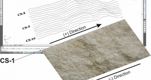
International Journal of Environment and Geoinformatics, 2016 Determining Roughness Angle of Limestone Using Optical Laser Scanner Avşar Emin Özgür, Bozkurtoğlu Erkan, Aydar Umut, Şeker Dursun Zafer, Kaya Şinasi, Gazioğlu Cem Abstract: In this study, a limestone rock core specimen with 6.94 cm x 4.95 cm dimensions was exposed to tensile …
Read More..The role of spatial analysis for aquaculture: a case study of Keban Dam lake
Fresenius Environmental Bulletin, 26(1), 405-412. (2017) The role of spatial analysis for aquaculture: a case study of Keban Dam lake Sivri, N., Seker, D.Z., Alganci, U., Basusta, N., Basusta, A., Akgun, H Abstract: Turkey is divided into 25 hydrologic basins depending on the topographic structure. These basins have different productivities …
Read More..Accuracy Assessment of Different Digital Surface Models
ISPRS International Journal of Geo-Information, 7(3), 114; (2018) Accuracy Assessment of Different Digital Surface Models Alganci, U.; Besol, B.; Sertel, E. Abstract: Digital elevation models (DEMs), which can occur in the form of digital surface models (DSMs) or digital terrain models (DTMs), are widely used as important geospatial information sources …
Read More..Single Frame Super Resolution of Remote Sensing Images By Convolutional Neural Networks
International Journal of Remote Sensing, 39:8, 2463-2479, DOI: 10.1080/01431161.2018.1425561, (2018) Single Frame Super Resolution of Remote Sensing Images By Convolutional Neural Networks Tuna, C, Unal, G. and Sertel, E. Abstract: Super resolution (SR) refers to generation of a high-resolution (HR) image from a decimated, blurred, low-resolution (LR) image set, which …
Read More..Dual Layer Convoluted Frequency Selective Surface Design in the 2.4 GHz and 5.8 GHz ISM Bands
Applied Computational Electromagnetics Society Journal, Volume: 33, Issue: 4, Pages: 413-418, Apr 2018, DOI: ISSN: 1054-4887 Dual Layer Convoluted Frequency Selective Surface Design in the 2.4 GHz and 5.8 GHz ISM Bands B. Doken, M. Kartal Abstract: ndoor wireless devices operating in 2.4 GHz and 5.8 GHz ISM bands have …
Read More..Recent Satellite Technologies for Soil Salinity Assessment with Special Focus on Mediterranean Countries
Fresenius Environmental Bulletin Journal, 26(1), 196-203 (2017) Recent Satellite Technologies for Soil Salinity Assessment with Special Focus on Mediterranean Countries Gorji, T., Sertel, E., Tanik, A. Abstract: Recent satellite technologies for soil salinity assessment with special focus on Mediterranean countries Gorji Taha1, Sertel Elif2, Tanik Aysegul1 1Faculty of Civil Engineering, …
Read More..