Publications in International Journals

Automated Orthorectification of VHR Satellite Images by SIFT based RPC Refinement

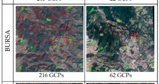
ISPRS International Journal of Geo-Information,  7(6), 229, (2018) Automated Orthorectification of VHR Satellite Images by SIFT based RPC Refinement Kartal, H., Alganci, U., Sertel, E. Abstract: Raw remotely sensed images contain geometric distortions and cannot be used directly for map-based applications, accurate locational information extraction or geospatial data integration. A …

Read More..

Dynamic monitoring of land coverchange: a recent study for Istanbul metropolitan area

Fresenius Environmental Bulletin, 28(2), 688-693 Dynamic monitoring of land coverchange: a recent study for Istanbul metropolitan area Shoman,W., Korkutan, M., Alganci, U., Tanik, A., Demirel, H. Abstract: In this study, the changes in land cover/use is detected using remote sensing, GIS and stochastic modelling for part of metropolitan Istanbul city. …

Read More..

Dual-band Frequency Surface Design by Implementing a Simple Design Technique

IETE Journal of Research (TIJR), 09 Dec. 2019 Dual-band Frequency Surface Design by Implementing a Simple Design Technique B. Doken, M. Kartal Abstract: Mutual interference between wireless devices in indoor environment reduces system performance. Ensuring secure personal communication within such wireless networks is also another important problem. Existing indoor surfaces can …

Read More..

Analyzing gridding systems for land cover/land use information: astudy conducted for green areas

Fresenius Environmental Bulletin, 28(2), 694-699 Analyzing gridding systems for land cover/land use information: astudy conducted for green areas Shoman,W., Alganci, U., Demirel, H. Abstract: Performing point-based land cover/use analysis traditionally compels converting thematic clusters into representative points located at their corresponding centroids. Yet, various spatial analyses require to grid thematic …

Read More..

Structural and dielectric performance of the Ba(Zn1/3Nb2/3-xSbx)O-3 perovskite ceramics

Materials Research Express, Vol: 6, Issue: 9, September 2019 Structural and dielectric performance of the Ba(Zn1/3Nb2/3-xSbx)O-3 perovskite ceramics Qasrawi, A. F., Sahin, E. I., Emek, M., Kartal, M. and Kargin, S. Abstract: In this work, we have explored the antimony doping effects on the structural and dielectric properties of Ba(Zn1/3Nb2/3)O3 ceramics …

Read More..

Triple-Band Frequency Selective Surface Design Effective Over Oblique Incidence Angles for GSM System

IETE Journal of Research (TIJR), 8 Aug. 2019 Triple-Band Frequency Selective Surface Design Effective Over Oblique Incidence Angles for GSM System J. J. Golezani, M. Kartal, B. Doken and S. Paker Abstract: A novel triple-band frequency selective surface (FSS) as a band stop filter in Global System for Mobile communication (GSM) …

Read More..

Comparing two different spatial interpolation approaches to characterize spatial variability of soil properties in Tuz Lake Basin – Turkey

Fresenius Environmental Bulletin Journal, 28(2), 2019 pages 638-644 –SCI Comparing two different spatial interpolation approaches to characterize spatial variability of soil properties in Tuz Lake Basin – Turkey Gorji, T., Alganci, U., Sertel, E., Tanik, A. Abstract: The main objective of this study is to compare the performance of two …

Read More..

An Approach for the Pan Sharpening of Very High Resolution Satellite Images Using a CIELab Color Based Component Substitution Algorithm

Applied Sciences, 9, 5234 An Approach for the Pan Sharpening of Very High Resolution Satellite Images Using a CIELab Color Based Component Substitution Algorithm Rahimzadeganasl, A.; Alganci, U; Goksel, C. Abstract: Recent very high spatial resolution (VHR) remote sensing satellites provide high spatial resolution panchromatic (Pan) images in addition to …

Read More..

Dynamic Land Cover Mapping of Urbanized Cities with Landsat 8 Multi-temporal Images: Comparative Evaluation of Classification Algorithms and Dimension Reduction Methods

ISPRS Int. J. Geo-Inf. 8(3), 139 Dynamic Land Cover Mapping of Urbanized Cities with Landsat 8 Multi-temporal Images: Comparative Evaluation of Classification Algorithms and Dimension Reduction Methods Alganci, U Abstract: Uncontrolled and continuous urbanization is an important problem in the metropolitan cities of developing countries. Urbanization progress that occurs due …

Read More..
CSCRS