Publications in International Journals

Monitoring Soil Salinity via Remote Sensing Technology Under Data Scarce Conditions: A Case Study From Turkey

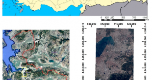
Ecological Indicators, 74, 384–391, (2017) Monitoring Soil Salinity via Remote Sensing Technology Under Data Scarce Conditions: A Case Study From Turkey Gorji, T., Sertel, E., Tanik, A. Abstract: Soil salinization is one of the severe land-degradation problems due to its adverse effects on land productivity. Each year severalhectares of lands …

Read More..

An Active Frequency Selective Surface Design Having Four Different Switchable Frequency Characteristics

Radioengineering, Volume 28, No. 1, Pages: 114-120, April 2019 An Active Frequency Selective Surface Design Having Four Different Switchable Frequency Characteristics B. Döken, M. Kartal Abstract: Mutual interference between indoor adjacent wireless networks is becoming an important issue due to reducing the communication speed significantly. Controlling the isolation of wireless …

Read More..

Characterization, Production and Microwave Absorbing Properties of Polyaniline-NiFe2O4: Tb composites

Journal Materials Science –Medziagotyra, Vol.25 No.3, Pages:322-327, Sept. 2019 Characterization, Production and Microwave Absorbing Properties of Polyaniline-NiFe2O4: Tb composites E. I. Sahin, S. Paker and M. Kartal Abstract: In this study, terbium-doped NiFe2O4 was produced by using mixed oxide technique. The Ni1-xTbxFe2O4 composition was synthesized and x was selected as 0.025, 0.050 …

Read More..

Assessment of The Relationship Between Land Use/Cover Changes and Land Surface Temperature: A case Study of Thermal Remote Sensing

Fresenius Environmental Bulletin, 28 (2), 541-547, (2019) Assessment of The Relationship Between Land Use/Cover Changes and Land Surface Temperature: A case Study of Thermal Remote Sensing Celik, B., Kaya, S., Alganci, U., Seker, D.Z. Abstract: Rapid and uncontrolled urbanization is one of the most important land cover change phenomenon, which …

Read More..

Spatial analysis of two different urban landscapes using satellite images and landscape metrics

Photogrammetric Engineering and Remote Sensing, 84(11), 711-721, (2018) Spatial analysis of two different urban landscapes using satellite images and landscape metrics Şimşek, D. and Sertel, E. Abstract: This research aims to compare landscape metrics of two different cities having distinct landscape characteristics by using up-to-date, very high resolution SPOT 6/7 …

Read More..
CSCRS