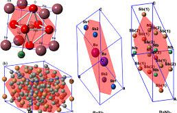
Int. J. Global Warming., 2019, 1758-2083, 19, 1-2, 94-105 Estimation of emissions from crop residue burning using remote sensing data Kubra Bahsi, Betul Sallı, Dogushan Kilic, Elif Sertel Abstract: Approximately one-fourth of the population in Turkey works in the agricultural sector. One common problem in agricultural waste removal is the …
Read More..Comparing two different spatial interpolation approaches to characterize spatial variability of soil properties in Tuz Lake Basin – Turkey
Fresenius Environmental Bulletin Journal, 28(2), 2019 pages 638-644 –SCI Comparing two different spatial interpolation approaches to characterize spatial variability of soil properties in Tuz Lake Basin – Turkey Gorji, T., Alganci, U., Sertel, E., Tanik, A. Abstract: The main objective of this study is to compare the performance of two …
Read More..Impacts of Land Cover/Use Changes on Hydrological Processes in a Rapidly Urbanizing Mid-latitude Water Supply Catchment
Water 2019, 11(5), 1075. -SCI Impacts of Land Cover/Use Changes on Hydrological Processes in a Rapidly Urbanizing Mid-latitude Water Supply Catchment Sertel, E.; Imamoglu, M.Z.; Cuceloglu, G.; Erturk, A. Abstract: This research aimed to evaluate the impact of land cover/use changes on watershed responses and hydrological processes by applying the …
Read More..Evaluation of the Relative Tectonic Activity of the Adıyaman fault within the Arabian-Anatolian plate boundary (eastern Turkey)
Geologica Acta, DOI: 10.1344/GeologicaActa2019.17.6, 17-6, 1-17, (2019) Evaluation of the Relative Tectonic Activity of the Adıyaman fault within the Arabian-Anatolian plate boundary (eastern Turkey) Khalifa, A., Çakır, Z., Owen, L., Kaya, Ş. Abstract: The left-lateral strike-slip Adıyaman fault is located in eastern Turkey within the plate boundary deformation zone between Arabia …
Read More..Calculation of Flood Risk Index for Yesilirmak Basin-Turkey
International Journal of Environment and Geoinformatics (IJEGEO), 6(3): 244-259 Calculation of Flood Risk Index for Yesilirmak Basin-Turkey Menteş E., Kaya, S., Tanik, A., Gazioglu, C. Abstract: Flood risk, in the sense of damage that a ‘flood event’ can cause, was globally indexed and quantified to show the relationship between various …
Read More..Remote sensing approaches and mapping methods for monitoring soil salinity under different climate regimes
International Journal of Environment and Geoinformatics, March 2019 Remote sensing approaches and mapping methods for monitoring soil salinity under different climate regimes Taha Gorji, Aylin Yildirim, Elif Sertel, Aysegul Tanik Abstract: Soil salinization is one of the severe land-degradation problems due to its adverse effects on land productivity. Each year …
Read More..Soil salinity analysis of Urmia Lake Basin using Landsat-8 OLI and Sentinel-2A based spectral indices and electrical conductivity measurements
Volume 112, May 2020, 106173 Soil salinity analysis of Urmia Lake Basin using Landsat-8 OLI and Sentinel-2A based spectral indices and electrical conductivity measurements T. Gorji, A. Yildirim, N. Hamzehpour, A. Tanik, E. Sertel Abstract: Soil salinization is one of the significant soil degradation problems especially faced in arid and …
Read More..ASTER spectral band ratios for lithological mapping: a case study for measuring geological offset along the Erkenek Segment of the East Anatolian Fault Zone, Turkey
Arabian Journal of Geosciences 13 (17), 1-8 ASTER spectral band ratios for lithological mapping: a case study for measuring geological offset along the Erkenek Segment of the East Anatolian Fault Zone, Turkey A. Khalifa, Z. Çakır, Ş. Kaya, S. Gabr Abstract: The current work examines the lithological variation along the …
Read More..Separating Built-Up Areas from Bare Land in Mediterranean Cities Using Sentinel-2A Imagery
Remote Sensing, 2019, 11, 345 Separating Built-Up Areas from Bare Land in Mediterranean Cities Using Sentinel-2A Imagery Ettehadi Osgouei, P., Kaya, Ş., Sertel, E., Alganci, U. Abstract: In this research work, a multi-index-based support vector machine (SVM) classification approach has been proposed to determine the complex and morphologically heterogeneous land …
Read More..Vineyard Site Suitability Analysis by use of Multi-Criteria Approach Applied on Geospatial Data
Geocarto International, 34(12), 1286-1299 Vineyard Site Suitability Analysis by use of Multi-Criteria Approach Applied on Geospatial Data Alganci, U, Kuru, G, Algan, I. Sertel, E. Abstract: In this research, multicriteria decision analysis with pairwise comparison weighting method was utilized to determine the suitable locations for vineyard plantation in Sarkoy region …
Read More..