Publications in International Journals

Determining Lateral Offsets of Rocks Along The Eastern Part of The North Anatolian Fault Zone (Turkey) Using Spectral Classification of Satellite Images and Field Measurements, Geomatics

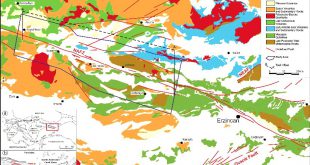
Geomatics, Natural Hazards and Risk,8 (2), 1276-1288. (2017) Determining Lateral Offsets of Rocks Along The Eastern Part of The North Anatolian Fault Zone (Turkey) Using Spectral Classification of Satellite Images and Field Measurements, Geomatics Gürsoy, Ö., Kaya, Ş., Cakir, Z.,Tatar, O., Canbaz, O. Abstract: Fault displacements are being measured by …

Read More..

Monitoring Soil Salinity via Remote Sensing Technology Under Data Scarce Conditions: A Case Study From Turkey

Ecological Indicators, 74, 384–391, (2017) Monitoring Soil Salinity via Remote Sensing Technology Under Data Scarce Conditions: A Case Study From Turkey Gorji, T., Sertel, E., Tanik, A. Abstract: Soil salinization is one of the severe land-degradation problems due to its adverse effects on land productivity. Each year severalhectares of lands …

Read More..

Assessment of The Relationship Between Land Use/Cover Changes and Land Surface Temperature: A case Study of Thermal Remote Sensing

Fresenius Environmental Bulletin, 28 (2), 541-547, (2019) Assessment of The Relationship Between Land Use/Cover Changes and Land Surface Temperature: A case Study of Thermal Remote Sensing Celik, B., Kaya, S., Alganci, U., Seker, D.Z. Abstract: Rapid and uncontrolled urbanization is one of the most important land cover change phenomenon, which …

Read More..

Spatial analysis of two different urban landscapes using satellite images and landscape metrics

Photogrammetric Engineering and Remote Sensing, 84(11), 711-721, (2018) Spatial analysis of two different urban landscapes using satellite images and landscape metrics Şimşek, D. and Sertel, E. Abstract: This research aims to compare landscape metrics of two different cities having distinct landscape characteristics by using up-to-date, very high resolution SPOT 6/7 …

Read More..

Automated Orthorectification of VHR Satellite Images by SIFT based RPC Refinement

ISPRS International Journal of Geo-Information,  7(6), 229, (2018) Automated Orthorectification of VHR Satellite Images by SIFT based RPC Refinement Kartal, H., Alganci, U., Sertel, E. Abstract: Raw remotely sensed images contain geometric distortions and cannot be used directly for map-based applications, accurate locational information extraction or geospatial data integration. A …

Read More..

An Active Frequency Selective Surface Design Having Four Different Switchable Frequency Characteristics

Radioengineering, Volume 28, No. 1, Pages: 114-120, April 2019 An Active Frequency Selective Surface Design Having Four Different Switchable Frequency Characteristics B. Döken, M. Kartal Abstract: Mutual interference between indoor adjacent wireless networks is becoming an important issue due to reducing the communication speed significantly. Controlling the isolation of wireless …

Read More..
CSCRS