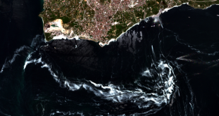
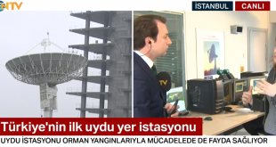
Turkey’s first satellite earth station ITU CSCRS has started a study to determine the distribution of mucilage in the Marmara Sea and the regions where it is concentrated. In this context, the mucilage distribution in the Sea of Marmara was monitored by the Pleiades, Spot 5 and Spot 6&7 satellites. …
Read More..Minister of Industry and Technology Mustafa VARANK Visited Our Center within the Scope of ITU Trip – 09.04.2021
Industry and Technology Minister Mustafa Varank visited our center as part of the ITU trip and received detailed information about the work done at our center.
Read More..The Destruction Caused by the Izmir Earthquake Viewed from Space – 05.11.2020
Istanbul Technical University (ITU) Satellite Communication and Remote Sensing Center (CSCRS) viewed the destruction caused by the 6.6-magnitude earthquake, whose epicenter is in the Seferihisar district of Izmir, from space. Aegean Sea, Izmir’s Seferihisar district open on 30 October at earthquake in Turkey the law drowns occurred at 14:51, after …
Read More..Turkey’s Covid-19 Remaining After Empty Square Viewed From Space – 17/04/2020
Istanbul Technical University (ITU) Satellite Communications and Remote Sensing Center (CSCRS), a new type of coronavirus (Covid-19) prior to the outbreak and after images taken by satellite, measures to that followed, crowded square in Turkey, visibly the coastal road and thoroughfare in a revealed that it was emptied in the …
Read More..Turkey’s First Satellite Ground Station Opens its Doors to NTV – 02.20.2020
Istanbul Technical University can receive satellite stations operating in the image anywhere in Turkey. The station, which monitors the damage caused by the 6.8-scale Elazig earthquake from the air, will be the eye of the search and rescue teams in the sky after the possible Istanbul earthquake. NTV Reporter Ahmet …
Read More..They Knocked the Door of the Satellite Center for Reconstruction Peace – 30.07.2019
The possibilities provided by satellite technologies are used in many areas from natural disasters to the development of agricultural products. Finally, satellite images were also used in the implementation of “zoning peace” regulation. The possibilities provided by satellite technologies are used in many areas from natural disasters to the development …
Read More..
CSCRS İTÜ – Center for Satellite Communications and Remote Sensing