Turkey’s first satellite earth station ITU CSCRS has started a study to determine the distribution of mucilage in the Marmara Sea and the regions where it is concentrated.
In this context, the mucilage distribution in the Sea of Marmara was monitored by the Pleiades, Spot 5 and Spot 6&7 satellites. Areas of mucilage in the Sea of Marmara were detected with image recordings taken from space.
The increase rate of mucilage in the Sea of Marmara was also determined in the satellite records that started to be taken as of March.
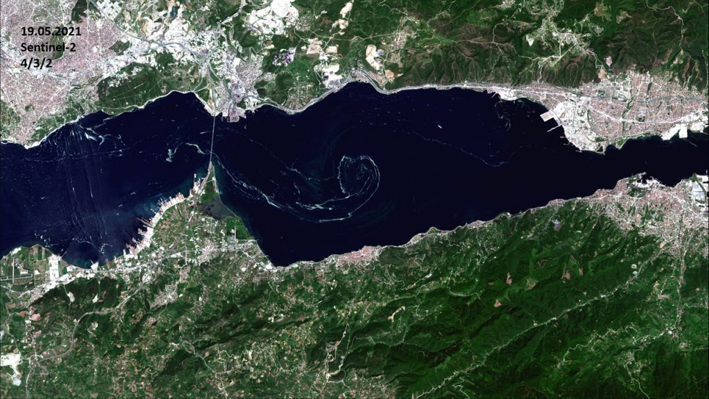
It was determined from satellite images that mucilage reached an area of 25 square kilometers on May 14, 58 square kilometers on May 19, and 85 square kilometers on May 24 in the eastern part of the Sea of Marmara from the Kapıdağ Peninsula to the Gulf of Izmit. It was observed that there was a mucilage increase of more than 3 times in 10 days in the said area.
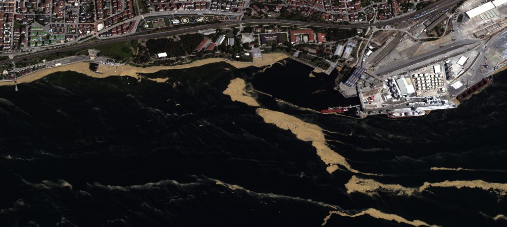
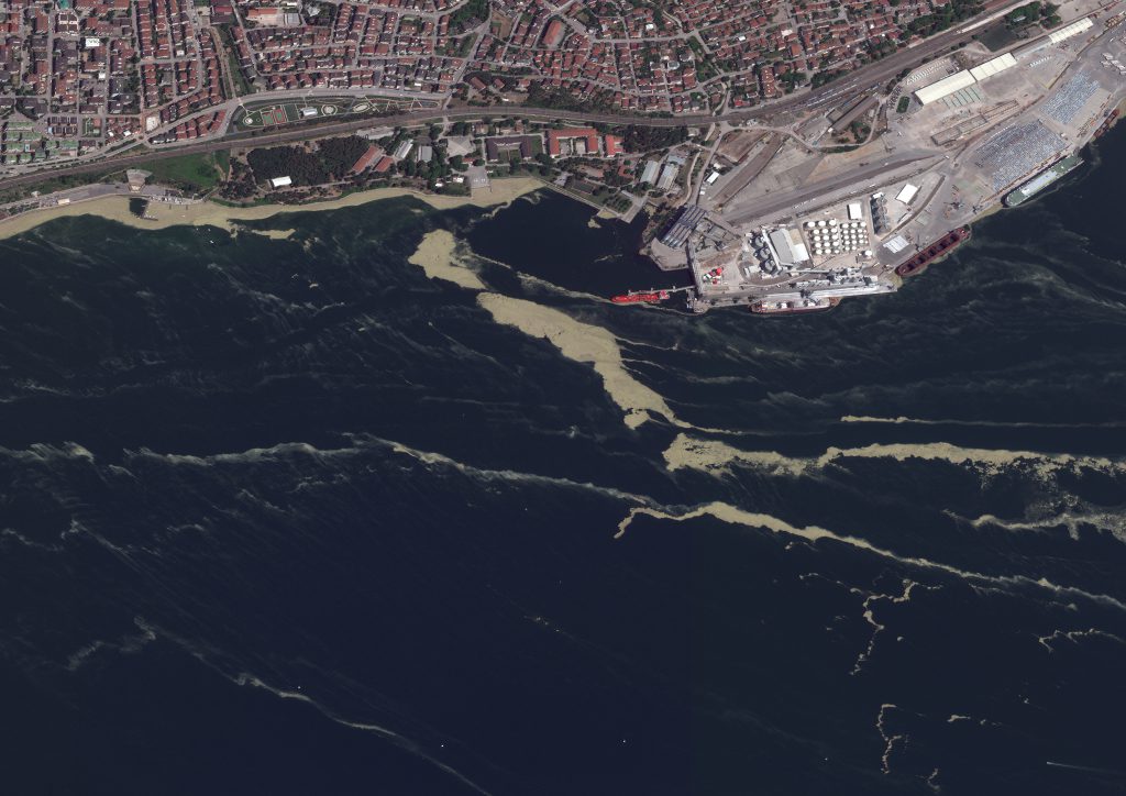
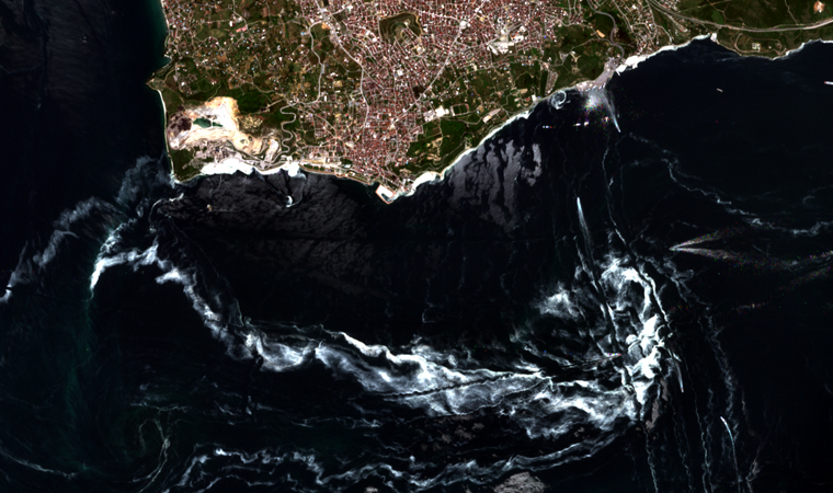
In satellite images, it was determined that mucilage was mostly found around the Gulf of Izmit and its surroundings, the coastal areas of the Anatolian Side of Istanbul and the Islands.
In high-resolution satellite images, it was seen that the mucilage was scattered piecemeal over the entire Sea of Marmara from time to time.
ITU CSCRS Director and ITU Civil Faculty Geomatics Engineering Department Head Prof. Dr. Mustafa Yanalak told Anadolu Agency (AA) that the establishment of ITU UZUHAM started as a project in 1996 and has gained the status of an Application and Research (UYG-AR) Center affiliated to ITU since 2003.
Stating that the images provided by ITU CSCRS are used by many academicians and students in their studies, Yanalak said, “With the increase in the accuracy and resolution of satellite images recently, the application areas have also increased. As academicians, we conduct academic studies on certain subjects that the society needs. We conducted a study on the examination of mucilage in the Sea of Marmara. We make this information available to the relevant institutions.” he said.
“MUCILAGE LOOKS VERY COMFORTABLE”
ITU CSCRS Deputy Director and ITU Civil Faculty Geomatics Engineering Department Lecturer Prof. Dr. Nebiye Musaoğlu also stated that satellite images can be used for a wide variety of purposes and that this opportunity exists in their centers.
Emphasizing that they are working in different application areas at ITU CSCRS, Musaoğlu said, “Our focus has shifted there recently due to the mucilage problem in the Marmara Sea. In this context, we started to investigate what is the situation in the Sea of Marmara.” said.
Informing that they have started to examine the Sea of Marmara with satellite images of different resolutions since March, Musaoğlu continued as follows:
“Using optical satellite images in the Marmara Region, we took images on cloudless days in temporal terms. Mucilage can be seen very easily in satellite images in the Marmara Region. We have seen that there are mucilage accumulations in the Izmit Bay entrance and its surroundings, the Anatolian Side of Istanbul and the Islands. We detected a significant increase across the Sea of Marmara. In the images, mucilage can be very clearly separated from normal water and other objects. These satellite images we have taken are very important for detecting mucilage and taking action on the spot. Satellite images are to determine the locations and distribution of mucilage, the areas that need to be intervened first It provides important information to be produced in terms of detection and monitoring of the results of the cleaning.
Source: https://www.aa.com.tr/tr/turkiye/marmara-denizindeki-musilaj-uzaydan-goruntulendi/2270288
