Istanbul Technical University (ITU) Satellite Communication and Remote Sensing Application and Research Center (CSCRS) has viewed the destruction caused by forest fires in the Mediterranean and Aegean Regions from space via satellite.
Turkey’s first satellite earth station, ITU CSCRS, has started a study to detect the destruction in nature after forest fires in the regions.
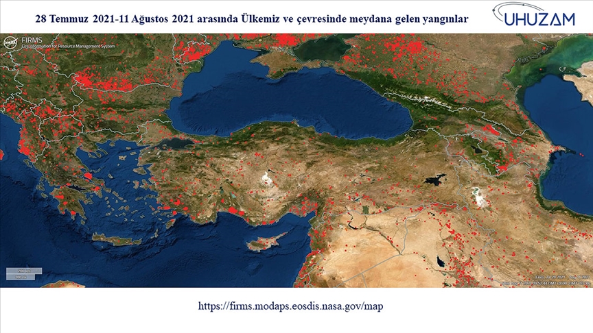
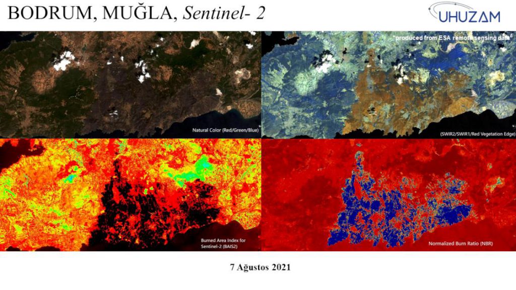
In this context, the damage caused by forest fires to nature was captured by the “Spot 6&7”, “Worldview 2&3” and “Sentinel-2” and “Landsat 8” satellites. The latest situation of the destruction of forest fires in nature was determined with images from space.
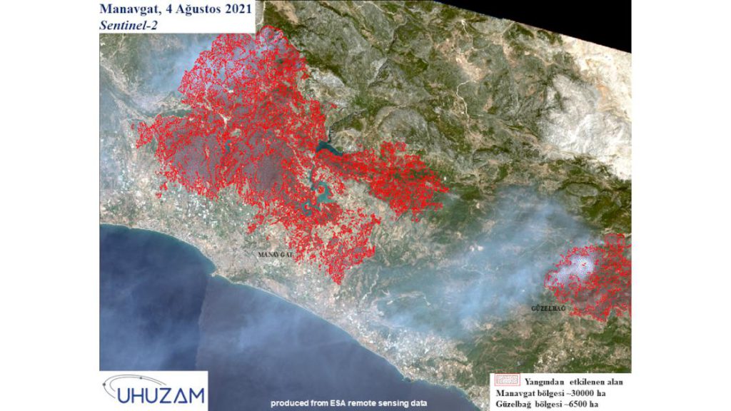
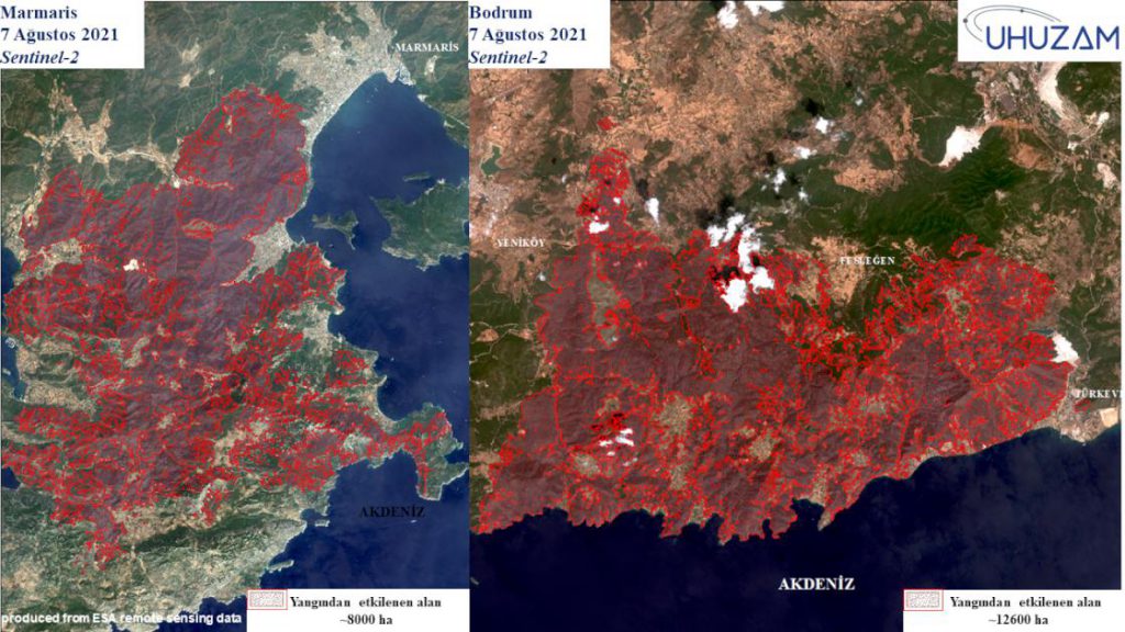
In satellite images, it was determined that the fires were most effective in Manavgat and Muğla.
The fires damaged 30 thousand hectares in Manavgat, 12 thousand 600 in Bodrum, 8 thousand in Marmaris and 6 thousand 500 hectares around Güzelbağ.
In the studies carried out with thermal bands, it was determined that the surface temperatures increased up to 90 to 100 degrees in forest fires.
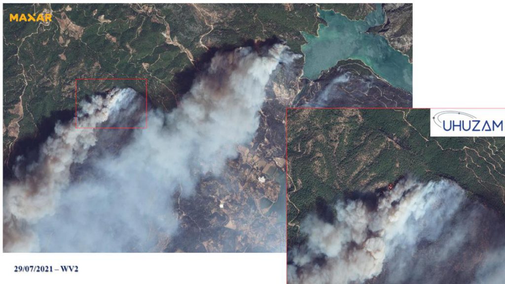
In high-resolution satellite images, it was determined that the fires started on July 28, continued intensely until August 9, and the fires still continued in some areas.
ITU CSCRSdetermined that an area the size of approximately 85 thousand football fields was burned in the places where it worked.
“Forest fires damaged Manavgat and Muğla the most”
ITU CSCRS Director and ITU Civil Faculty Geomatics Engineering Department Head Prof. Dr. Mustafa Yanalak told Anadolu Agency (AA) that they continue to work as a university-affiliated application and research center.
Stating that they started a study to determine the destruction caused by fires in the Mediterranean and Aegean Regions, Prof. Dr. Yanalak said, “We focused on 2 regions where fires are common in the studies. According to studies, there is an increase in fires in our country in parallel with the fires around the world. Especially, 2-9 August. There were forest fires all over Turkey.” said.
Prof. Dr. Yanalak stated that ITU CSCRS carried out detailed studies on forest fires especially in Manavgat, Bodrum and Marmaris.
Noting that they determined that there was a jump in this year’s forest fires, Prof. Dr. “We found that approximately 160 thousand hectares of land were burned in the forest fires in 2021 in Turkey. We saw that the surface temperatures increased up to 90 to 100 degrees in forest fires. Forest fires damaged the Manavgat and Muğla regions the most.” made its assessment.
Prof. Dr. Yanalak stated that they will share the studies with the scientific world and mentioned that the satellites from which the images were taken are very high resolution.
Underlining that the data they obtained from the studies are very important, Prof. Dr. Yanalak said, “We monitored the fire situation with different satellites and obtained information depending on the temporal resolution.” he said.
Source: https://www.dha.com.tr/istanbul/itu-orman-yanginlarinin-biraktigi-hasari-uydudan-tespit-etti/haber-1842677
