Bilişim Enstitüsü, Uydu Haberleşme ve Uzaktan Algılama Programı, İTÜ
Aircraft detection from large scale remote sensing images with deep learning techniques
Mehmet Soydaş; Elif Sertel, 2019
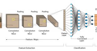
Abstract: Computer vision and artificial intelligence are not new fields in people’s lives. In order to automate the problems in our lives in a way that does not require human resources, problem-specific morphological methods were investigated and tried over the years. Recently, these morphological approaches have been replacing by deep learning methods in many fields thanks to the hardware which came up with high computational power, a vast amount of data in the digital world and rapid development of machine learning and deep learning algorithms. As in every field, these methods are also used in the analysis of remotely sensed images and their usage is becoming more widespread. The analysis of satellite images plays a very important role in many areas such as defining forest areas and fires, monitoring of cultivated areas in agricultural lands, city and road planning, security and military surveillance, disaster and crisis management. Considering the satellite images, which can cover many square kilometers of areas, it is very costly and time-consuming to perform these analyzes by people. In addition, in order to obtain accurate results, it is also necessary, that the people to be used for these tasks, must be experts in their field. Regard all, it is expected that the obtained computer vision system should give both fast results and at least as much accurate as of the people. In the analysis of satellite images, computer vision solutions are categorized into three main topics as classification, segmentation and object detection. Classification and segmentation are examined in the sub-topics as pixel-based classification, scene classification, semantic segmentation, and instance segmentation. In all these analyses, convolutional neural network(CNN), a deep learning architecture which utilizes the spatial and spectral correlations on the image can be used and high performances can be achieved. In this study, aircraft detection from satellite imageries with deep architectures and traditional methods was discussed. Different object detection algorithms based on deep learning approaches were trained and tested. For the evaluation, the images containing airport areas were manually labeled. A detection flow algorithm was developed for large scale satellite images for rapid detection and high accuracy. The effects of using different architectures and the effects of training methods on the performance were investigated.

Tez No: 565495