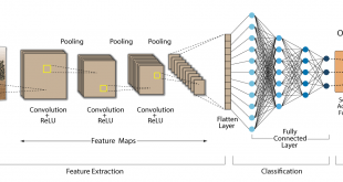
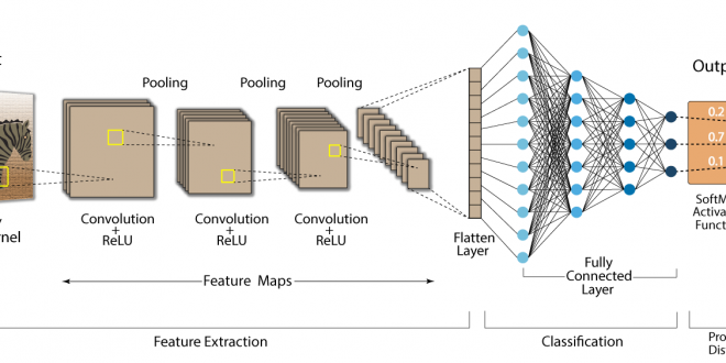
IEEE Transactions on Geoscience and Remote Sensing, : IEEE Transactions on Geoscience and Remote Sensing Print ISSN: 0196-2892 Online ISSN: 1558-0644 Digital Object Identifier: 10.1109/TGRS.2020.3010441. Rethinking CNN-Based Pansharpening: Guided Colorization of Panchromatic Images via GANs F. Ozcelik, U. Alganci, E. Sertel and G. Unal Abstract: Convolutional neural network (CNN)-based approaches …
Devamını Oku..Uluslararası Dergilerdeki Yayınlar
Comparative Research on Deep Learning Approaches for Airplane Detection from Very High-Resolution Satellite Images
Remote Sensing, Vol. 12, No. 3, 458, 2020 Comparative Research on Deep Learning Approaches for Airplane Detection from Very High-Resolution Satellite Images U. Alganci, M. Soydas, E. Sertel Abstract: Object detection from satellite images has been a challenging problem for many years. With the development of effective deep learning algorithms …
Devamını Oku..Soil salinity analysis of Urmia Lake Basin using Landsat-8 OLI and Sentinel-2A based spectral indices and electrical conductivity measurements
Volume 112, May 2020, 106173 Soil salinity analysis of Urmia Lake Basin using Landsat-8 OLI and Sentinel-2A based spectral indices and electrical conductivity measurements T. Gorji, A. Yildirim, N. Hamzehpour, A. Tanik, E. Sertel Abstract: Soil salinization is one of the significant soil degradation problems especially faced in arid and …
Devamını Oku..ASTER spectral band ratios for lithological mapping: a case study for measuring geological offset along the Erkenek Segment of the East Anatolian Fault Zone, Turkey
Arabian Journal of Geosciences 13 (17), 1-8 ASTER spectral band ratios for lithological mapping: a case study for measuring geological offset along the Erkenek Segment of the East Anatolian Fault Zone, Turkey A. Khalifa, Z. Çakır, Ş. Kaya, S. Gabr Abstract: The current work examines the lithological variation along the …
Devamını Oku..Separating Built-Up Areas from Bare Land in Mediterranean Cities Using Sentinel-2A Imagery
Remote Sensing, 2019, 11, 345 Separating Built-Up Areas from Bare Land in Mediterranean Cities Using Sentinel-2A Imagery Ettehadi Osgouei, P., Kaya, Ş., Sertel, E., Alganci, U. Abstract: In this research work, a multi-index-based support vector machine (SVM) classification approach has been proposed to determine the complex and morphologically heterogeneous land …
Devamını Oku..Vineyard Site Suitability Analysis by use of Multi-Criteria Approach Applied on Geospatial Data
Geocarto International, 34(12), 1286-1299 Vineyard Site Suitability Analysis by use of Multi-Criteria Approach Applied on Geospatial Data Alganci, U, Kuru, G, Algan, I. Sertel, E. Abstract: In this research, multicriteria decision analysis with pairwise comparison weighting method was utilized to determine the suitable locations for vineyard plantation in Sarkoy region …
Devamını Oku..Impacts of Land Cover/Use Changes on Hydrological Processes in a Rapidly Urbanizing Mid-latitude Water Supply Catchment
Water 2019, 11(5), 1075. -SCI Impacts of Land Cover/Use Changes on Hydrological Processes in a Rapidly Urbanizing Mid-latitude Water Supply Catchment Sertel, E.; Imamoglu, M.Z.; Cuceloglu, G.; Erturk, A. Abstract: This research aimed to evaluate the impact of land cover/use changes on watershed responses and hydrological processes by applying the …
Devamını Oku..Evaluation of the Relative Tectonic Activity of the Adıyaman fault within the Arabian-Anatolian plate boundary (eastern Turkey)
Geologica Acta, DOI: 10.1344/GeologicaActa2019.17.6, 17-6, 1-17, (2019) Evaluation of the Relative Tectonic Activity of the Adıyaman fault within the Arabian-Anatolian plate boundary (eastern Turkey) Khalifa, A., Çakır, Z., Owen, L., Kaya, Ş. Abstract: The left-lateral strike-slip Adıyaman fault is located in eastern Turkey within the plate boundary deformation zone between Arabia …
Devamını Oku..Calculation of Flood Risk Index for Yesilirmak Basin-Turkey
International Journal of Environment and Geoinformatics (IJEGEO), 6(3): 244-259 Calculation of Flood Risk Index for Yesilirmak Basin-Turkey Menteş E., Kaya, S., Tanik, A., Gazioglu, C. Abstract: Flood risk, in the sense of damage that a ‘flood event’ can cause, was globally indexed and quantified to show the relationship between various …
Devamını Oku..Remote sensing approaches and mapping methods for monitoring soil salinity under different climate regimes
International Journal of Environment and Geoinformatics, March 2019 Remote sensing approaches and mapping methods for monitoring soil salinity under different climate regimes Taha Gorji, Aylin Yildirim, Elif Sertel, Aysegul Tanik Abstract: Soil salinization is one of the severe land-degradation problems due to its adverse effects on land productivity. Each year …
Devamını Oku..-
Aktif uzaktan algılama verileri ve CBS destekli hidrolojik model kullanılarak Büyükçekmece havzasının incelenmesi
Fen Bilimleri Enstitüsü, Geomatik Mühendisliği Programı, İTÜ Aktif uzaktan algılama verileri ve CBS destekli hidrolojik model kullanılarak Büyükçekmece havzasının incelenmesi …
Devamını Oku.. -
Gezgin haberleşme sistemleri için yalın zamanlama algoritması
-
Düzey II bölgelerinde kalkınma modeli oluşturmada coğrafi bilgi sistemlerinin rolü: Lucis modeli yaklaşımı
-
Katkılı NiFe2O4 polimer tabanlı mikrodalga yutucuların frekans seçici malzeme tasarımı
-
Spot 6 uydu görüntüleri üzerinde uzaktan algılama sınıflandırma yöntemleriyle orman arazisinde azalma tespiti
Fen Bilimleri Enstitüsü, Geomatik Mühendisliği Programı, İTÜ Spot 6 uydu görüntüleri üzerinde uzaktan algılama sınıflandırma yöntemleriyle orman arazisinde azalma tespiti …
Devamını Oku.. -
Uydu görüntü verileri kullanılarak orman yangın şiddeti ve yangın sonrası durumun zamansal olarak incelenmesi: Akdeniz bölgesi örneği
-
Arazi örtüsü/kullanımının Landsat 5 TM verileri ve indisler yardımıyla analizi
-
Güncel arazi örtüsü/kullanım haritalarının doğrudan ve dolaylı yaklaşımlar ile üretilmesi
-
Mısır ve pamuk ekili alanların çok zamanlı uydu görüntüleri ve obje tabanlı sınıflandırma yöntemi ile tespiti