Bilişim Enstitüsü, Uydu Haberleşme ve Uzaktan Algılama Programı, İTÜ
Super resolution methods for remote sensing images
Çağlayan Tuna; Elif Sertel, 2017
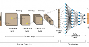
Abstract: This thesis aims at enhancing the spatial resolution of single or multi frame remote sensing images. This process is referred to as super resolution (SR) image reconstruction in the literature. Application of multi frame super resolution to real data presents challenges due to the very high dimensions of the datasets, such as those obtained in RS satellite imaging and due to the impacts of atmospheric, topographic, land cover charateristics and sun-sensor-geometry during the data acquisition. Besides, multi-frame super resolution for remote sensing images is not common because of lack of data. In this thesis, a novel application of tri-stereo RS satellite images based on regularization method to the super resolution problem is proposed. Since the tri-stereo RS images of the same observation area are acquired from three different viewing angles along the flight path of the satellite, these RS images are properly suited to a SR application. For multi frame super resolution, regularization methods which are Total Variation and Tikhonov are used to preserve edges. The second contribution of the thesis is deep learning based single frame super resolution. Two pre-trained convolutional neural network models, SRCNN and VDSR, are applied to remote sensing images after IHS transform. Since this implementation is single frame super resolution, disadvantages of topography or moving objects doesn’t effect the results such multi frame super resolution does; therefore, method can be applied to all kind of areas such as mountainous regions. Methods are implemented to Intenstiy channel only, then colour information is restored with an inverse IHS transformation. As data, SPOT and Pleiades satellites images which are acquired by ITU Center for Satellite Communications and Remote Sensing (CSCRS) are used. Pleiades 1A, 1B RS satellite images having 0.5 m product spatial resolution for panchromatic mode and 2.0 m product spatial resolution for multispectral mode that include 4 spectral bands (Red, Green, Blue and IR); and SPOT 6 , SPOT 7 RS satellite images, which have 1.5 m and 6.0 m product spatial resolution for panchromatic and multispectral modes respectively. Structural Similarity Index (SSIM), Peak Signal Noise Ratio (PSNR), Spectral Angle Mapper (SAM) and ERGAS values are calculated for a quantitative evaluation of the methods, which showed satisfactory results with synthetic low resolution images. Finally, the method which gave better results, is tested within a real scenario, i.e. with original low resolution images and the obtained high resolution images demonstrated visible qualitative enhancements.

Tez No: 472640